Slovenian Centre of Excellence for Space Sciences and Technologies Space-SI
The Slovenian Centre of Excellence for Space Sciences and Technologies SPACE-SI has been established in 2010 by a consortium of academic institutions, high-tech SMEs and large industrial and insurance companies in order to benefit from the advantages of small satellite technologies and applications in Earth observation, meteorology and astrophysics.
The RTD activities of SPACE-SI are focused on high resolution interactive remote sensing and formation flying missions. These goals are supported by the development of an advanced microsatellite for Earth observation and RTD infrastructure that includes ground control infrastructure, satellite integration facilities as well as a multidisciplinary laboratory for testing of satellite systems and components in simulated space environments.
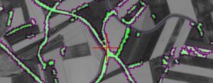
The data sources from small satellite missions have been combined with the data from large space programs such as Copernicus to enable frequent and cost-effective remote sensing applications in ecology, agriculture, forestry, land cover mapping, urbanism and maritime, as well as for monitoring climate changes, natural disasters and use of natural resources.