Slovenia from Space
A project Slovenia from Space has been launched at The Centre of Excellence SPACE-SI. We have invited the Slovenian secondary schools to deal with environmentally oriented topics in local area with Space based solutions. The objective of the project is to introduce space topics to the general public and to highlight Slovenian effort for the integration into international research of space sciences and technologies as well.
More about project.
Poster represented at the Small Satellites Systems and Services – The 4S Symposium in Portorož from July 4 to 8, 2012.
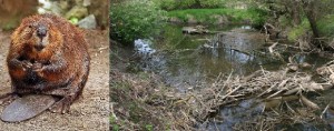
The aim of this research was to find the beaver dam. Due to their inaccessibility, remote sensing has been used for their determination. Beavers can be found on the basis of specific characteristic of their living environment.
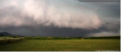
The aim of our research was to present the major windthrow that occured on the 13th of July, 2008 and damaged mountain pass Črnivec. Specifically, we examined the damaged forest areas with the use of remote sensing data, effects of planned and preventive reforesting as well as the reconstruction of buildings and roads.
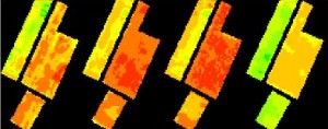
The Normalized Difference Vegetation Index (NDVI) is used to analyse remote sensing measurements. It shows the activity of a chlorophyll, which is directly connected with growth and development of a plant, and soil fertility. For this reason, our hypothesis predicted a connection between soil fertility/suitability and the NDVI index.
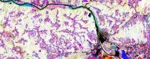
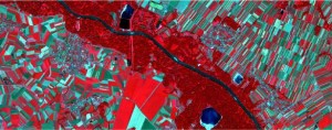
Our research paper focuses on the changes regarding Krško in the period from 1984 to 2011. Particular interest was placed upon urban sprawl, the changes in the bed of the Sava River and major construction developments conducted on the river.
The company Impol d.o.o., located in Slovenska Bistrica, which produces satellite castings, has the ambition of creating the best possible alloy (with all required properties) for the satellite operation. Their work has been studied by a group of students.
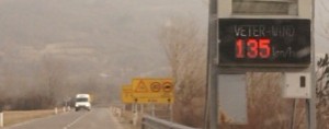
Bora is a strong and severe wind of great impact in the south-eastern region of Slovenia. We studied bora gusts by using new observations collected during the four-month period in 2012. On less than 2 km distance, bora velocity more than doubles. We compared bora forecasts of the SPACE-SI prognostic model with the observations.
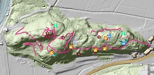
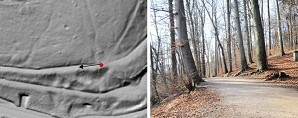
The research paper presents the hill Der, which had a supporting role during World War I. Its relief was examined and found that is, despite its simplicity, something special. A great help to us was the LIDAR based digital terrrain model.
A group of students decided to write an application using the Java Programming Language, which would compare two satellite images and show differences in a new perspective. It actually does so by indicating patches in shades of red in the new image. We have clearly succeeded in doing so.
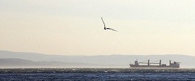
Spills at sea are a common occurrence in today’s shipping lanes. Oceans and seas are choked with fully laden ships, causing a tremendous impact on the fragile marine life and ecosystem. The biggest concern for life on and under the seas is oil pollution, which is becoming a big problem. This is an occurrence that usually happens on accident; however, there are deliberate polluters out there as well.
There is a considerable difference of lot sizes and shapes on the Mura river banks. The reason for this are natural factors, influence of people and the differences in farming. The aim of this research is to numerically define the differences of lot characteristics, such as area and elongation. For calculating this values, two specific areas have been analized.
The research focused on the urbanization growth in Slovenska Bistrica during the period from 1991 to 2011. It also searched for the clear-cuts in the Pohorje mountains. Both were done by use of the image comparison method of Landsat images. Some of our findings were also checked and confirmed by means of identification in the natural environment, using photographic evidence.
Japanese knotweed is, listed by the World Conservation Union one of the world’s 100 worst invasive species. In the town Naklo, Japanese knotweed has spread severly in the last 5 years, especially near rivers, roads and building sites. In this project we analysed remote sensing techniques on which determination and mapping of its distribution is based on.
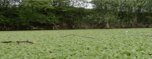
The aim of this research was to find the main reasons for the spread of the Water Lettuce (Pistia stratiotes) in the topla stream area (Čatež ob Savi).
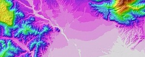
In the research paper we present a new tectonic and structural interpretation of the South Alpine Thrust Fault in the Central Slovenia, between the Kropa village and Kamnik.
In the research we analysed the suitability of LIDAR digital terrain model (DTM) for the analysis of paths in the Landscape park Rožnik, Tivoli in Šišenski hrib in the Centre of Ljubljana, the capital city of Slovenia.
Our research project presents two ways to control and stabilize satellites. We developed two models of satellites that are suspended in a magnetic field. In the first model we used a reaction wheel and in the second a pair of gyros (SGCMG).
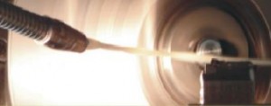
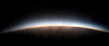
The goal of the project was to make an atmospheric probe and equip it with different sensors, living micro organisms, a parachute and a helium baloon, and two high resolution cameras. The probe was lifted to an altitude of 32 km; during the ascent some of the data was transmitted via the GSM signal, and the rest was collected after the fall.
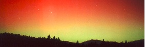
Aurora borealis is a common phenomenon in high latitude (Arctic and Antarctic) regions. When particular conditions are fulfilled it can be also observed at lower latitudes, as in Slovenia. In our research we obtained threshold values for aurora to be seen at our latitudes and tried to determine what is the frequency of auroras in Slovenia.